
Sierra Nevada Winter Storm warning issued as heavy snow, strong winds, and possible highway closures threaten travel on I-80 and Highway 50, with up to 48 inches expected this week.
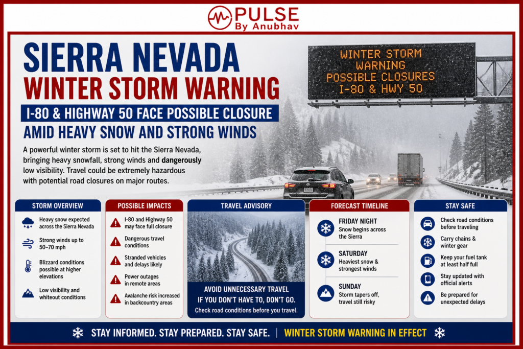
A powerful Sierra Nevada Winter Storm is set to bring heavy snowfall, strong winds, and dangerous travel conditions across key mountain routes. With up to 4 feet of snow expected on higher peaks and snow levels dropping sharply, roads like I-80 over Donner Pass and Highway 50 face possible closures. Authorities warn of low visibility, icy conditions, and strict chain controls. Travelers are advised to prepare for delays or avoid travel as conditions worsen through early week — updates covered by Pulse by Anubhav.
Also Read- Who Is Akanksha Choudhary Splitsvilla Contestant? Survives Elimination as Zalak & Ron Get Dumped
Sierra Nevada Winter Storm Warning: Travel Risk Rises as Heavy Snow and Strong Winds Hit Key Routes
Storm Setup: What’s Causing This Sierra Nevada Winter Storm
A powerful Pacific low-pressure system is now pushing deep moisture into the Sierra Nevada, with levels running nearly 90% above normal. That’s a big reason why this system is turning into a serious Sierra Nevada Winter Storm Warning situation.
Meteorologists are already flagging this as a high-impact event, especially for mountain regions where conditions can shift very quickly.
Snowfall and Wind: How Intense Will It Get
This storm is not light at all. Forecasts show:
Snowfall Expectations
- Up to 4 feet of snow on the highest peaks
- Around 1–2 feet above 6,000 feet
- Heavy accumulation even in areas that usually stay snow-free this time of year
Wind Impact
- Gusts reaching 50–70 mph along the Sierra crest
- Isolated gusts could even touch 80 mph in exposed areas
When you combine heavy snow + strong wind, visibility drops fast — and that’s where things get dangerous.
Travel Alert: Why Roads Like I-80 and Highway 50 Are at Risk
This Sierra Nevada Winter Storm is already making travel risky, especially on:
High-Risk Routes
- I-80 over Donner Pass – high chance of long closures
- Highway 50 over Echo Summit – heavy delays expected
- Highway 395 (Eastern Sierra) – icy and dangerous conditions
Snow levels are expected to fall sharply from 7,000 feet to around 4,500 feet, meaning more roads will be impacted than usual.
Officials are warning that the “heaviest snow period” will cause major visibility issues — not ideal for mountain driving at all.
Official Warning: NWS Issues Strong Advisory
The National Weather Service (NWS) has clearly stated that travel could become extremely difficult.
- Tire traction will be reduced
- Chain controls will likely be enforced
- Road closures are very possible
Caltrans is already preparing strict regulations, and conditions can change hour by hour.
Safety Tip
If you absolutely have to travel:
- Carry flashlight, food, and water
- Be ready for sudden stops or closures
- Don’t rely only on AWD — tires matter more
Also read- Emergency Alerts in India: What is Cell Broadcast Alert & Why You Received an Alert Message
Timing: When This Storm Will Hit the Hardest
Snow has already started at higher elevations, but the real impact window is:
Peak Impact Period
- Sunday night → Monday
- Continues strongly into Tuesday (May 5)
During this time:
- Snow levels drop तेजी से
- Accumulation increases rapidly
- Road conditions worsen quickly
The Weather Prediction Center has already upgraded the heavy snow risk to HIGH, which is a serious signal.
Road Status Right Now (Quick Update)
- I-80 (Donner Pass): Open, but chain controls expected soon
- US-50 (Echo Summit): Open, delays likely overnight
- US-395: Open, but strong winds impacting travel
- Tioga Pass: Closed (seasonal)
- Sonora Pass: Conditions worsening at summit
Closures can happen anytime — so don’t depend on current status for long.
Biggest Concern: No Alternate Routes
Here’s the real problem —
If I-80 and Highway 50 both close at the same time, there’s basically no reliable way to cross the Sierra.
That’s why this storm is being taken very seriously.
What Changed in the Last 24 Hours
Forecast models have become more aggressive:
- Heavy snow risk upgraded to HIGH for Monday & Tuesday
- Storm confidence has increased
- Impact area has widened
This means earlier forecasts actually underestimated the situation.
Next 48 Hours: What to Expect
- Snow level drops to ~6,000 ft (Monday)
- Further drops to ~4,500 ft (Tuesday)
- Heaviest snowfall from Sunday night → Tuesday afternoon
Closures of major passes are now very likely, not just possible.
Important Reminder: Tires Matter More Than You Think
A lot of drivers make the same mistake every year — especially in May.
Key Points
- All-season tires = still need chains under R2 rules
- Summer tires = dangerous below 45°F
- AWD ≠ safety without proper grip
Only proper winter tires truly perform in these conditions.
Final Take (Pulse by Anubhav)
This Sierra Nevada Winter Storm Warning is not your usual late-season snowfall. With up to 48 inches of snow, strong winds, and high closure risk, travel across the Sierra could become nearly impossible for a time.
If you’re planning to move through this region — rethink, delay, or prepare seriously.
Stay updated, stay safe — more real-time updates coming your way on Pulse by Anubhav 🔥
Also Read- Who Is Juhi Bhatt? Meet Ranveer Allahbadia’s Girlfriend, Influencer & Model
3 thoughts on “Sierra Nevada Winter Storm Warning: I-80 & Highway 50 Face Possible Closure Amid Heavy Snow and Strong Winds”